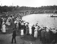
 What happened to the old swimming hole? - In 1920s Sulphur Springs was a booming Mediterranean style resort. The neighborhood had it's own hotel, movie theater, restaurant, hardware store, bank and street cars brought visitors from Tampa to visit the spring fed swimming hole and scenic area surrounding Hillsborough River.
Fifty years later bulldozers showed up and despite protests of local citizens, demolished the old hotel to make space for a dog track parking lot.
Today only the renovated movie theater, the white ornate gazebo and some dusty old postcards remind us of the old days.
"Modern" Sulphur Springs appear to suffer the same fate many close to downtown neighborhoods are: boarded up storefronts, congested traffic and in great need of TLC.
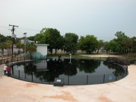
What happened to the swimming hole?
City of Tampa built and maintains a beautiful swimming pool complete with slide, picnic areas, changing rooms and lifeguards; all that right next to the old spring.
The round pool surrounding the original spring itself has been fenced off, it's overflow being directed to Hillsborough River and when the need arises some water is pumped out to support the city water supplies.
The spring discharges from a low horizontal crack in limestone at 30 feet and the flow's strength changes according to local rains. But for cave explorers trying to squeeze thru this restriction, the flow is always strong enough to require use of a pull rope and some very clever gear and gas management techniques.
The original explorers in early 1990s considered use of scooters in this cave questionable due to poor visibility and limited space but they were able to explore and survey over 3000 feet of passage.
 The exploration was renewed in early 2002 at the request of the City of Tampa and Coastal Karst Foundation team led by Michael Garman continues exploring beyond where the main passage splits into the Orchid Tunnel and the Alaska Tunnel. The divers equipped with water quality detection instruments discovered a vent discharging salt water into the Alaska Tunnel.
Radiolocation and GIS were used to reference the exact location of the tunnels to the surface features and we are hoping to get answers to where is the salt water coming from as well as what are the sources of pollution.